
Bangladesh is a low-lying, riverine country located in South Asia with a largely marshy jungle coastline of 710 km (441 mi) on the northern littoral of the Bay of Bengal. Formed by a delta plain at the confluence of the Ganges (Padma), Brahmaputra (Jamuna), and Meghna Rivers and their tributaries, Bangladesh's alluvial soil is highly fertile, but vulnerable to flood and drought. Hills rise above the plain only in the Chittagong Hill Tracts in the far southeast and the Sylhet division in the northeast. Straddling the Tropic of Cancer, Bangladesh has a tropical monsoon climate characterized by heavy seasonal rainfall, high temperatures, and high humidity. Natural disasters, such as floods, tornadoes, and tidal bores affect the country yearly. Bangladesh also is affected by major cyclones, on average 16 times a decade. A cyclone struck the southeastern coast in May 1991, killing 136,000 people. Cyclone Sidr struck the southwestern coast on November 15, 2007, affecting not only the coastal districts of the administrative division Khulna but also about half of the tropical forest Sundarbans.

Map of Bangladesh
Physical geography
Physical Overview
Most of the areas of Bangladesh lies
within the broad delta formed by the Ganges and Brahmaputra rivers.
Lands are exceedingly flat, low-lying, and subject to annual flooding.
Much fertile, alluvial soil is deposited by the floodwaters. The only
significant area of hilly terrain, constituting less than one-tenth of
the nation's territory, is the Chittagong Hill Tracts in the narrow
southeastern panhandle of the country. There, on the border with Burma,
is Mowdok Mual (1003 m/3292 ft), the country's highest peak. Small,
scattered hills lie along or near the eastern and northern borders with
India. The eroded remnants of two old alluvial terraces-the Madhupur
Tract, in the north central part of the country, and The Barind,
straddling the northwestern boundary with India- attain elevations of
about 30 m (about 100 ft). The soil here is much less fertile than the
annually replenished alluvium of the surrounding floodplain.
Land
Total area: 144,000 square kilometers;
Land area: 133,910 square kilometers
Land boundaries: 4,246 km total; 193 km
with Myanmar, 4,053 km with India, Coastline: 580 km.
Land distribution:
- arable land 67%
- forest and woodland 16%
- permanent crops 2%
- meadows and pastures 4%
- others 11%

The physical geography of Bangladesh is varied and has an area characterized by two distinctive features: a broad deltaic plain subject to frequent flooding, and a small hilly region crossed by swiftly flowing rivers.The country has an area of 147,570 square kilometers and extends 820 kilometers north to south and 600 kilometers east to west. Bangladesh is bordered on the west, north, and east by a 4,095-kilometer land frontier with India and, in the southeast, by a short land and water frontier (193 km) with Burma (Myanmar). On the south is a highly irregular deltaic coastline of about 580 kilometers, fissured by many rivers and streams flowing into the Bay of Bengal. The territorial waters of Bangladesh extend 12 nautical miles (22 km), and the exclusive economic zone of the country is 200 nautical miles (370 km). Roughly 80% of the landmass is made up of fertile alluvial lowland called the Bangladesh Plain. The plain is part of the larger Plain of Bengal, which is sometimes called the Lower Gangetic Plain. Although altitudes up to 105 meters above sea level occur in the northern part of the plain, most elevations are less than 10 meters above sea level; elevations decrease in the coastal south, where the terrain is generally at sea level. With such low elevations and numerous rivers, water—and concomitant flooding—is a predominant physical feature. About 10,000 square kilometers of the total area of Bangladesh is covered with water, and larger areas are routinely flooded during the monsoon season. The only exceptions to Bangladesh's low elevations are the Chittagong Hills in the southeast, the Low Hills of Sylhet in the northeast, and highlands in the north and northwest. The Chittagong Hills constitute the only significant hill system in the country and, in effect, are the western fringe of the north-south mountain ranges of Burma and eastern India. The Chittagong Hills rise steeply to narrow ridge lines, generally no wider than 36 meters, with altitudes from 600 to 900 meters above sea level. At 1,052 meters altitude, the highest elevation in Bangladesh is found at Mowdok Mual, in the southeastern part of the hills. Fertile valleys lie between the hill lines, which generally run north-south. West of the Chittagong Hills is a broad plain, cut by rivers draining into the Bay of Bengal, that rises to a final chain of low coastal hills, mostly below 200 meters, that attain a maximum elevation of 350 meters. West of these hills is a narrow, wet coastal plain located between the cities of Chittagong in the north and Cox's Bazar in the south. About 67% of Bangladesh's nonurban land is arable. Permanent crops cover only 2%, meadows and pastures cover 4%, and forests and woodland cover about 16%. The country produces large quantities of quality timber, bamboo, and sugarcane. Bamboo grows in almost all areas, but high-quality timber grows mostly in the highland valleys. Rubber planting in the hilly regions of the country was undertaken in the 1980s, and rubber extraction had started by the end of the decade. A variety of wild animals are found in the forest areas, such as in the Sundarbans on the southwest coast, which is the home of the Royal Bengal Tiger. The alluvial soils in the Bangladesh Plain are generally fertile and are enriched with heavy silt deposits carried downstream during the rainy season.
Human geography
Urbanization is proceeding rapidly, and it is estimated that only 30% of
the population entering the labor force in the future will be absorbed
into agriculture, although many will likely find other kinds of work in
rural areas. The areas around Dhaka and Comilla
are the most densely settled. The Sundarbans, an area of coastal
tropical jungle in the southwest and last wild home of the Bengal Tiger, and the Chittagong Hill Tracts on
the southeastern border with Burma and India, are the least densely
populated.
Climate
Bangladesh has a tropical monsoon climate
characterized by wide seasonal variations in rainfall, high
temperatures, and high humidity. Regional climatic differences in this
flat country are minor. Three seasons are generally recognized: a hot,
muggy summer from March to June; a hot, humid and rainy monsoon season
from June to November; and a warm-hot, dry winter from December to
February. In general, maximum summer temperatures range between 38 and
41 °C (100.4 and 105.8 °F). April is the hottest month in most parts of
the country. January is the coolest month, when the average temperature
for most of the country is 16–20 °C (61–68 °F) during the day and around
10 °C (50 °F) at night. . Winds are mostly from the north and northwest in the winter, blowing
gently at 1 to 3 kilometers per hour (0.6 to 1.9 mph) in northern and
central areas and 3 to 6 kilometers per hour (1.9 to 3.7 mph) near the
coast. From March to May, violent thunderstorms, called northwesters by
local English speakers, produce winds of up to 60 kilometers per hour
(37.3 mph). During the intense storms of the early summer and late
monsoon season, southerly winds of more than 160 kilometers per hour
(99.4 mph) cause waves to crest as high as 6 meters (19.7 ft) in the Bay
of Bengal, which brings disastrous flooding to coastal areas.
Heavy rainfall is characteristic of Bangladesh causing it to flood
every year. With the exception of the relatively dry western region of
Rajshahi, where the annual rainfall is about 1,600 mm (63.0 in), most
parts of the country receive at least 2,300 mm (90.6 in) of rainfall per
year. Because of its location just south of the foothills of the
Himalayas, where monsoon winds turn west and northwest, the region of
Sylhet in northeastern Bangladesh receives the greatest average
precipitation. From 1977 to 1986, annual rainfall in that region ranged
between 3,280 and 4,780 mm (129.1 and 188.2 in) per year. Average daily
humidity ranged from March lows of between 55 and 81% to July highs of
between 94 and 100%, based on readings taken at selected stations
nationwide in 1986. About 80% of Bangladesh's rain falls during the monsoon season. The
monsoons result from the contrasts between low and high air pressure
areas that result from differential heating of land and water. During
the hot months of April and May hot air rises over the Indian
subcontinent, creating low-pressure areas into which rush cooler,
moisture-bearing winds from the Indian Ocean. This is the southwest
monsoon, commencing in June and usually lasting through September.
Dividing against the Indian landmass, the monsoon flows in two branches,
one of which strikes western India. The other travels up the Bay of
Bengal and over eastern India and Bangladesh, crossing the plain to the
north and northeast before being turned to the west and northwest by the
foothills of the Himalayas. Natural calamities, such as floods, tropical cyclones, tornadoes, and
tidal bores—destructive waves or floods caused by flood tides rushing
up estuaries—ravage the country, particularly the
coastal belt, almost every year. Between 1947 and 1988, 13 severe
cyclones hit Bangladesh, causing enormous loss of life and property. In
May 1985, for example, a severe cyclonic storm packing
154-kilometre-per-hour (95.7 mph) winds and waves 4 meters (13.1 ft)
high swept into southeastern and southern Bangladesh, killing more than
11,000 persons, damaging more than 94,000 houses, killing some 135,000
head of livestock, and damaging nearly 400 kilometers (248.5 mi) of
critically needed embankments. Annual monsoon flooding results in the loss of human life, damage to
property and communication systems, and a shortage of drinking water,
which leads to the spread of disease. For example, in 1988 two-thirds of
Bangladesh's 64 districts experienced extensive flood damage in the
wake of unusually heavy rains that flooded the river systems. Millions
were left homeless and without potable water. Half of Dhaka, including
the runway at the Shahjalal International Airport—an important transit
point for disaster relief supplies—was flooded. About 2,000,000 tonnes
(2,204,623 short tons; 1,968,413 long tons) of crops were reported
destroyed, and relief work was rendered even more challenging than usual
because the flood made transportation of any kind exceedingly
difficult. A tornado in
April 1989 killed more than 600 people, possibly many more. There are no precautions against cyclones and tidal bores except
giving advance warning and providing safe public buildings where people
may take shelter. Adequate infrastructure and air transport facilities
that would ease the sufferings of the affected people had not been
established by the late 1980s. Efforts by the government under the Third
Five-Year Plan (1985–90) were directed toward accurate and timely
forecast capability through agrometeorology, marine meteorology,
oceanography, hydrometeorology, and seismology. Necessary expert
services, equipment, and training facilities were expected to be
developed under the United Nations Development Programme.
Rivers and Lakes

Bangladesh is a land of rivers that
crisscrossed throughout the mostly flat territories of the country. They
include hundreds of brooks and a good number of big ones. The Ganges
(Ganga) is known as the Padma below the point where it is joined by the
Jamuna River, the name given to the lowermost portion of the main
channel of the Brahmaputra. The combined stream is then called the
Meghna below its confluence with a much smaller tributary of the same
name. In the dry season the numerous deltaic distributaries that lace
the terrain may be several kilometers wide as they near the Bay of
Bengal, whereas at the height of the summer monsoon season they coalesce
into an extremely broad expanse of silt-laden water. In much of the
delta, therefore, homes must be constructed on earthen platforms or
embankments high enough to remain above the level of all but the highest
floods. In non-monsoon months the exposed ground is pocked with
water-filled borrow pits, or tanks, from which the mud for the
embankments was excavated. Throughout the country there are bils, haors
and lakes that meet the need of drinking, bathing and irrigating water.
River systems

Ganges River Delta, Bangladesh and India
The rivers of Bangladesh mark both the physiography of the nation and
the life of the people. About 700 in number, these rivers generally
flow south. The larger rivers serve as the main source of water for
cultivation and as the principal arteries of commercial transportation.
Rivers also provide fish, an important source of protein. Flooding of
the rivers during the monsoon season causes enormous hardship and
hinders development, but fresh deposits of rich silt replenish the
fertile but overworked soil. The rivers also drain excess monsoon
rainfall into the Bay of Bengal. Thus, the great river system is at the
same time the country's principal resource and its greatest hazard. The profusion of rivers can be divided into five major networks. The
Jamuna-Brahmaputra is 292 kilometers long and extends from northern
Bangladesh to its confluence with the Padma. Originating as the Yarlung
Tsangpo River in China's Xizang Autonomous Region (Tibet) and
flowing through India's state of Arunachal Pradesh, where it becomes
known as the Brahmaputra ("Son of Brahma"), it receives waters from five
major tributaries that total some 740 kilometers in length. At the
point where the Brahmaputra meets the Tista River in Bangladesh, it
becomes known as the Jamuna. The Jamuna is notorious for its shifting
subchannels and for the formation of fertile silt islands (chars). No
permanent settlements can exist along its banks. The second system is the Padma-Ganges, which is divided into two
sections: a 258-kilometer segment, the Ganges, which extends from the
western border with India to its confluence with the Jamuna some 72
kilometers west of Dhaka, and a 126-kilometer segment, the Padma, which
runs from the Ganges-Jamuna confluence to where it joins the Meghna
River at Chandpur. The Padma-Ganges is the central part of a deltaic
river system with hundreds of rivers and streams—some 2,100 kilometers
in length—flowing generally east or west into the Padma. The third network is the Surma-Meghna River System, which
courses from the northeastern border with India to Chandpur, where it
joins the Padma. The Surma-Meghna, at 669 kilometers by itself the
longest river in Bangladesh, is formed by the union of six lesser
rivers. Below the city of Kalipur it is known as the Meghna. When the
Padma and Meghna join together, they form the fourth river system—the
Padma-Meghna—which flows 145 kilometers to the Bay of Bengal. This mighty network of four river systems flowing through the
Bangladesh Plain drains an area of some 1.5 million square kilometers.
The numerous channels of the Padma-Meghna, its distributaries, and
smaller parallel rivers that flow into the Bay of Bengal are referred to
as the Mouths of the Ganges. Like the Jamuna, the Padma-Meghna and
other estuaries on the Bay of Bengal are also known for their many
chars.
A fifth river system, unconnected to the other four, is the
Karnaphuli. Flowing through the region of Chittagong and the Chittagong
Hills, it cuts across the hills and runs rapidly downhill to the west
and southwest and then to the sea. The Feni, Karnaphuli, Sangu, and
Matamuhari—an aggregate of some 420 kilometers—are the main rivers in
the region. The port of Chittagong is situated on the banks of the
Karnaphuli. The Karnaphuli Reservoir and Karnaphuli Dam are located in
this area. The dam impounds the Karnaphuli River's waters in the
reservoir for the generation of hydroelectric power.
During the annual monsoon period, the rivers of Bangladesh flow at
about 140,000 cubic meters per second, but during the dry period they
diminish to 7,000 cubic meters per second. Because water is so vital to
agriculture, more than 60% of the net arable land, some 91,000 km², is
cultivated in the rainy season despite the possibility of severe
flooding, and nearly 40% of the land is cultivated during the dry winter
months. Water resources development has responded to this "dual water
regime" by providing flood protection, drainage to prevent overflooding
and waterlogging, and irrigation facilities for the expansion of winter
cultivation. Major water control projects have been developed by the
national government to provide irrigation, flood control, drainage
facilities, aids to river navigation and road construction, and
hydroelectric power. In addition, thousands of tube wells and electric
pumps are used for local irrigation. Despite severe resource
constraints, the government of Bangladesh has made it a policy to try to
bring additional areas under irrigation without salinity intrusion. Water resources management, including gravity flow irrigation, flood
control, and drainage, were largely the responsibility of the Bangladesh
Water Development Board. Other public sector institutions, such as the
Bangladesh Krishi Bank, the Bangladesh Rural Development Board, the
Bangladesh Bank, and the Bangladesh Agricultural Development Corporation
were also responsible for promotion and development of minor irrigation
works in the private sector through government credit mechanisms.
Area and boundaries
Area:
total: 147,570 km²
country comparison to the world: 94
land: 133,910 km²
water: 10,090 km²
total: 147,570 km²
country comparison to the world: 94
land: 133,910 km²
water: 10,090 km²
Area comparative:
- Australia comparative: 1.5 times larger than Tasmania
- Canada comparative: twice the size of New Brunswick
- United Kingdom comparative: larger than England
- United States comparative: slightly larger than Iowa
Land boundaries:
total: 4,246 km
border countries: Myanmar 193 km, India 4,053 km
total: 4,246 km
border countries: Myanmar 193 km, India 4,053 km
Coastline: 580 km
Maritime claims:
contiguous zone: 18 nmi (33.3 km; 20.7 mi)
continental shelf: up to the outer limits of the continental margin
exclusive economic zone: 200 nmi (370.4 km; 230.2 mi)
territorial sea: 12 nmi (22.2 km; 13.8 mi)
contiguous zone: 18 nmi (33.3 km; 20.7 mi)
continental shelf: up to the outer limits of the continental margin
exclusive economic zone: 200 nmi (370.4 km; 230.2 mi)
territorial sea: 12 nmi (22.2 km; 13.8 mi)
Elevation extremes:
lowest point: Indian Ocean 0 m
highest point: In the Mowdok range at 1052 m (at N 21°47'12" E 92°36'36"), NOT Keokradong (883 m not 1,230 m) or Tajingdong (985 m not 1,280 m as sometimes reported)
lowest point: Indian Ocean 0 m
highest point: In the Mowdok range at 1052 m (at N 21°47'12" E 92°36'36"), NOT Keokradong (883 m not 1,230 m) or Tajingdong (985 m not 1,280 m as sometimes reported)
Resources and land Use
Natural resources: Natural
gas, Arable land, Timber, Coal
Land use:
Arable land: 55.39%
Permanent crops: 3.08%
other: 41.53% (2005)
Arable land: 55.39%
Permanent crops: 3.08%
other: 41.53% (2005)
Irrigated land: 47,250 km² (2003)
Total renewable water resources: 1,210.6 km³ (1999)
Freshwater withdrawal (domestic/industrial/agricultural):
total: 79.4 km³/yr (3%/1%/96%)
per capita: 560 m³/yr (2000)
total: 79.4 km³/yr (3%/1%/96%)
per capita: 560 m³/yr (2000)
Flora and Fauna
Chittagong Hill Tracts,
portions of the Madhupur Tract, and the Sundarbans (a great tidal
mangrove
forest in the southwestern corner of the country) are principal
vegetation in
Bangladesh. The wooded area amount to less than one-sixth of the total
area.
Broadleaf evergreen species characterize the hilly regions, and
deciduous trees,
such as acacia and banyan, are common in the drier plains areas.
Commercially
valuable trees in Bangladesh include sundari (hence the name
Sundarbans), gewa,
sal (mainly growing in the Madhupur Tract), and garan (in the Chittagong
Hill
Tracts). Village groves inslude fruit trees (mango and jackfruit, for
instance)
and date and areca (betel) palms. The country also has many varieties of
bamboo. Bangladesh is rich in
fauna, including nearly 250 indigenous species of mammals, 750 types of
birds,
150 kinds of reptiles and amphibians, and 200 varieties of marine and
freshwater
fish. The rhesus monkey is common, and gibbons and lemurs are also
found. The Sundarbans area is
one of the principal remaining domains of the Royal Bengal tiger, and
herds of
elephants and many leopards inhabit the Chittagong Hill Tracts. Other
animals
living in Bangladesh include mongoose, jackal, Bengal fox, wild boar,
parakeet,
kingfisher, vulture, and swamp crocodile.
Geographic Features
Bangladesh is situated in South Asia between India and Myanmar. With an area of 148,393 sq. km and a population of approx. 130 million, it occupies the apex of the arch formed by the Bay of Bengal into which drain a large number of rivers and their tributaries crisscrossing the country and making it a very fertile delta. However, a dominant feature of life is the annual cycle of overabundance of water in the monsoon and its scarcity in winter. But the phenomenon changes dramatically during the winter months of November to May when the flows in the three major rivers- Ganges, Brahmaputra and Meghna - decrease considerably and most of the streams and channels almost dry up leading to shortage of fresh water for use in agriculture, fishery, navigation and industries as well as for domestic use. Normal floods are regarded as highly beneficial for revitalizing the cropland. The people have also learnt the coping strategies to minimize their adverse effects. Various measures have been taken in the past to cope with the effects of catastrophic floods but not always effectively. Comprehensive multi-national studies have been made during the recent years under the World Bank coordinated Flood Action Plan to find more effective ways to mitigating such floods without causing environmental hazards.
Quick look
Location: Southern Asia, bordering the Bay of Bengal, between Burma and India.
Geographic coordinates: 24 00 N, 90 00 E.
Map references: Asia
Area:
total: 144,000 sq km.
land: 133,910 sq km.
water: 10,090 sq km.
Area-comparative: slightly smaller than Iowa.
Land boundaries:
total: 4,246 km
border countries: Burma 193 km, India 4,053 km
Coastline: 580 km.
Maritime claims:
contiguous zone: 18 nm.
continental shelf: up to the outer limits of the continental margin.
exclusive economic zone: 200 nm.
territorial sea: 12 nm.
Climate: tropical; mild winter (October to March); hot, humid summer (March to June); humid, warm rainy monsoon (June to October)
Terrain: mostly flat alluvial plain; hilly in southeast.
Elevation extremes:
lowest point: Indian Ocean 0 m.
highest point: Keokradong 1,230 m.
Natural resources: natural gas, arable land, timber.
Land use:
arable land: 61%
permanent crops: 3%
other: 36% (1998 est.)
Irrigated land: 38,440 sq km (1998 est.)
Natural hazards: droughts, cyclones; much of the country routinely flooded during the summer monsoon season.
Environment-current issues: many people are landless and forced to live on and cultivate flood-prone land; limited access to potable water; water-borne diseases prevalent; water pollution especially of fishing areas results from the use of commercial pesticides; intermittent water shortages because of falling water tables in the northern and central parts of the country; soil degradation; deforestation; severe overpopulation.
Environment-international agreements:
party to: Biodiversity, Climate Change, Climate Change-Kyoto Protocol, Desertification, Endangered Species, Environmental Modification, Hazardous Wastes, Law of the Sea, Nuclear Test Ban, Ozone Layer Protection, Wetlands signed, but not ratified: none of the selected agreements
Transnational Issues
Disputes-international: Only a small portion of the boundary with India remains undelimited; discussions to demarcate the boundary, exchange 162 miniscule enclaves, and allocate divided villages remain stalled; skirmishes, illegal border trafficking, and violence along the border continue; Bangladesh has protested India's attempts to fence off high traffic sections of the porous boundary; Burmese attempts to construct a dam on the border stream in 2001 prompted an armed response halting construction; Burmese Muslim refugees migrate into Bangladesh straining meager resources.
Seasons
Traditionally Bangladeshis subdivide the
year into six seasons: Grismo (summer), Barsha (rainy), Sharat (autumn),
Hemanto (Late
autumn), Sheet (winter), and Bashonto (spring). For practical
purposes, however, three seasons are distinguishable: summer , rainy,
and winter.
Summer season in bangladesh
Throughout basanto, the weather warms up a bit each day until March 1, when the heat starts intensifying more rapidly. The soil turns a dusty khaki and then almost white. There are lightening and thunder storms and sometimes, icy lumps of hail crash down. The rivers dry out and are difficult to navigate. Grisma is also the peak time for the brick industry. Bricks are used for building and are a substitute for stone and gravel in Bangladesh. In the cities, the humid air is laden with dust, brick grit and auto fumes. The sun is a round red globe, beating down relentlessly. Everyone waits for the rains and the beginning of another cycle of seasons.


Summer Season in bangladesh
Rainy Season of Bangladesh
In Bangladesh, which has both the world’s largest delta system and the greatest flow of river water to the sea, water rules the earth, and so the most important season of all is barsa, a time of lashing rains and tearing winds. In this season, 70 percent of the land is under water – water from rivers, the sea, rain, tidal waves, floods and the melting snows of the Himalayas. The rains are at first a welcome relief from the baking, dusty hot season. But as the rains continue, the land turns into a brown and watery mass, ever-changing in shape and texture. Fields and homes are flooded; people and animals have to move to higher ground. Food is reduced to pre-cooked rice, dal and jackfruit that ripen at this time. During the rains, most villages are isolated, accessible only by boat. The people become self-sufficient and depend on each other rather than the outside world. The rain has turned stagnant water fresh again. Children leap naked into ponds. Women swim in sarees. Men dive in wearing sarongs. It is during the rainy season that Bangladesh’s main crop, jute, begins to ripen and is harvested. Farmers dive down to the roots to cut them. The stalks are placed on high ground to dry. Aside from the practical problems, the rains and water also inspire the poetry, art and songs of the people.

Bangladesh is a land of six seasons. The rainy in one of the them. It comprise the Bengli month of Ashar and Sravan. After a long spell of hot weather, the rainy season comes with showers to cool the earth. Our economy, culture and way of life are loosely related to it. The rainy season is caused by monsoon. The south west monsoon that a bole over Bangladesh from the Bay of Bengal brings many vapors with it. As a result, there occurs heavy rainfall during the monsoon in our country. During the rainy season the sky often remains overcast with thick black lauds that cover across the sky close to the earths suffers surface. Violent blasts of wind blow, lighting, flasher and thunder roar.

The sun remains hidden behind of the clouds
and it rains in torrents. Sometimes, there is continuous rain for days
together. The low lying lands go under water and look like a vast sheet
of water. The rainy season undoubtedly does must good to us. Name
assumes a new appearance at the advent of the rainy season. The
landscape appears green. The rainwater washes away the filth and
purifies the surface of the earth. It lessons the intense heat of
summer.

It makes our land alluvial, fertile and
suitable for growing better crops. The atmosphere becomes clean and free
of dust. The rainy season in not an unmixed blessing all the times. It
has disadvantage too. During the season the roads in the countryside
become muddy and slippery and as such people can not go from one place
to other place foot easily. Sometimes heavy rainfall overflows the banks
of the rivers and causes floods, which damage our crops, cattle, houses
and properties. But whatever the demerits of the rainy season, it is
the most important and useful season in our country. The prosperity and
development of our agriculture, which is the heart of our economy
largely, depend on the mercy of the rainy season. The people of
Bangladesh always welcome it and like to enjoy its beauty.
Autumn season of bangladesh
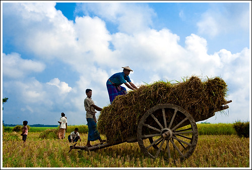
As September begins, the skies are blue and a cool wind blows. The land turns into a carpet of bright green rice shoots while the smell of drying jute invades the air. Flowers bloom, the rice ripens and the harvest begins. Blue, gold and green are the colours of sarat – blue sky, golden sun and green vegetation from emerald to jade, pea to lime, shamrock to sea-green. In the green fields, white Siberian cranes, egrets and ducks hunt for food. Although the air is humid, there is a slight chill late at night.
As September begins, the skies are blue and a cool wind blows. The land
turns into a carpet of bright green rice
shoots while the smell of drying jute invades the air. Flowers bloom,
the rice
ripens and the harvest begins. Blue, gold and green are the colours of
sarat – blue sky, golden sun and green vegetation from emerald to jade,
pea to lime, shamrock to sea-green. In the green fields, white Siberian
cranes, egrets and ducks hunt for food. Although the air is humid, there
is a slight chill late at night.
It is the 3rd season out of six seasons. This season says in bangla
time “Kartik-Aughrohaun ". Late-Autumn season times from a half of month
in October to a half of month in December. It comes after autumn
season. This time is covered by a gloomy air of all over the area.
Late-autumn is only crops. So farmers are cutting down own crops in
himself fields. It is the season dwell and more happily. They are always
busy for harvesting in own crops.
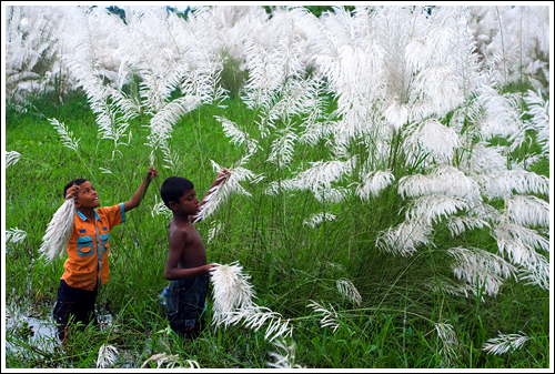
The early autumn season of Shorot
comes in Bhadro
and Ashwin. Shorot is
characterised by clearing
skies at the end of the Monsoons
above,
and below is the pungent odour
emitted from
golden jute collected and
processed by farmers
on every piece of available dry
land. Then
Hemonto swings through the fields
of Bengal
with cooler days in the months of
Kartik
and Ograhayon. Farmers take to
clearing
harvested fields to make way for
winter
crops and the iconic bucolic
beauty of Bengal
takes shape in both these seasons
where
the landscape is laced with
Shaplas and
Kashphools in full bloom.
Late Autumn Season of Bangladesh

Once the land has emerged from its watery grave, it is time to replant
in new, fertile soil that is rich in nutrients. During this season, the
land is at its luscious best. Festivals flourish to hail the harvest,
the end of the floods, the coming of the new soil and the wonder of the rivers.
The country’s troubadours are everywhere, dressed in bright clothes and
singing for money. The land and its people
come to life during hemanto, when the flowers bloom – jasmine, water
lily, rose, magnolia, hibiscus and bougainvillea. By the season’s end,
the air is no longer humid. Fresh scents replace the dry jute smell.
Hemanto marks the start of the wedding season where receptions are held under red, blue, green or white tents.
Hemanto marks the start of the wedding season where receptions are held under red, blue, green or white tents.
Winter Season of Bangladesh

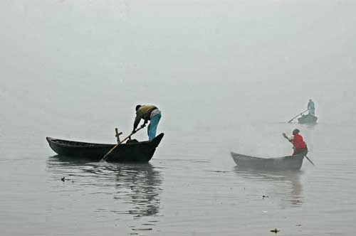
From mid-November to early January, the weather becomes more arid and less humid. The earth dries and dust forms. Warm clothes are pulled out. Young people play tennis, football, cricket and golf. Seet is also the season when people return to their ancestral villages, where they can experience once again the essence of Bangladesh – the harmony of man, beast, land, water and air.
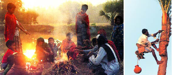
Winter brings about a change
in nature. At advent of winter, nature becomes dull and gloomy. The
leaves of some trees whither at touch its icy hand. Days gradually
become shorter and nights become longer. Cold wind blows continuously
from the north. The morning often remains foggy and something nothing
can be seen even at a little distance. The sky often remains cloudless
and the rays of the sun become very mild. The dew drops fallen on the
grass look glittering pearls when the rays of morning sun fall on them.
The old and the poor are often seen to bask in the sun in order to warm
themselves.

During this season, different kinds of the
fresh vegetables, fruits and fishes are found available inn the market.
The roads in the rural areas remain dry. So, it convenient time for
holding picnics, festival, social functions and various and various
kinds of out door games and spots. The general health of th people
remain in a good condition. People can get extra energy for working hard
and live better. It is the season that hurdles the advent of spring.
But this season is not an unmixed blessing. The poor people suffer
greatly from cold for want of warm clothes. The old and the children
often shiver biting cold. Every year some old people die because of
server cold. Even the animals, birds, worms, and insects feel the pinch
of cold.
Spring season of bangladesh

The coolest days are from mid-December to February when the days are
golden with light, the flowers are blooming and the nights and early
mornings are chilly. Night guards wrap themselves up in shawls and
blankets with scarves and hats pulled down over their ears. During
basanto, the countryside hums with fairs, parades and commemorations.
Arts festivals celebrate painting and handicrafts, poetry, music and
drama. In Dhaka,
basanto heralds the beginning of the social season with a frantic whirl
of invitations to weddings, parties and dinners. Along with the cool weather
comes the nation’s silly season – politics. To a Bangladeshi, politics
is what alcohol or sport is to other nations. Everyone gets involved.
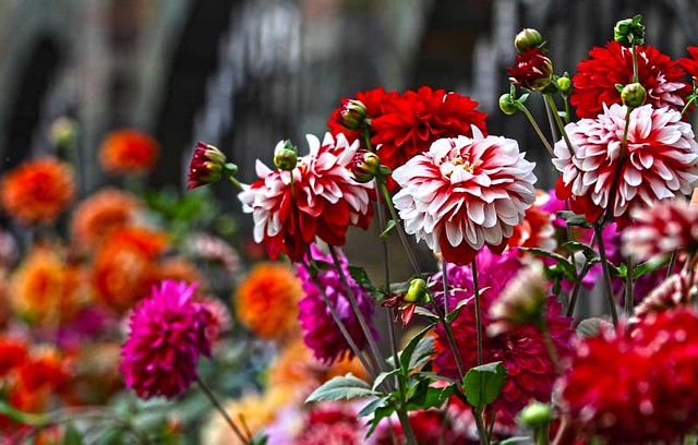
Each season appears with it's own beauty, color, sign and sound. Pahela
Falgoon the first day of Falgoon the 11th month of Bangla calendar
marks the beginning of "Boshonto" the spring season in the country and
it has special significance in the Bangladeshi culture. Spring is
the king of the season. Nature looks bright and charming. Trees and
plants put their new leaves and twigs on. Most Flowers start to bloom,
the Marygold flowers fill the garden's joy. The birds are happy and
start singing their melodious songs.

Boshonto utshab is a
traditional festival to welcome the spring. Each year thousands of
people come to Dhaka the capital city of Bangladesh to enjoy this
biggest, colorful celebration from different parts of the country. Folk
dances, folk music, Rabindra sangit,Nazrul geeti, drama, recitations and
the rallies throughout the city is the main attractions of the spring
festival. Traditionally Bangladeshi people celebrate this occasion
wearing yellow color dresses, called "bashoti rang",caring flower on
their hands, wearing Marygold flower ornaments , as well as singing
spring songs. Some people even paint their faces to make the celebration
more interesting. Spring is the most attractive season which brings
color and festivities in the lives of Bangladeshi people.
No comments:
Post a Comment