Beautiful Place in Bangladesh

Everyone views beauty in different ways and what one person considers
to be beautiful may be completely different to how other people view
it.
These beautiful
places from all around the world are, in their own right,
beautiful. Consisting of everything from individual monuments to
expanses of water and ancient villages to modern cities, they may not
all be attracting, appealing or aesthetically pleasing to everyone, but
to some, they are some of the most stunning places on earth.
Shrine of Bayazid Bostami

Bayazid Bostami was a famous Persian Sufi born in Bostam, Iran. There is a Shrine on his name located in Chittagong, Bangladesh known as Bayazid Bostami Dargah Sharif. It is a complex consists of a tomb surrounded by brick made structure along with an old mosque and a large pond. The whole complex is located on a hillock of Nasirabad, considered to be a holy place and attracted by a large number of visitors and pilgrims daily.
World War II Cemetery


Bangladesh
has two Cemetery for World War II. One is at Chittagong, and another is
at Comilla. I was there at Friday, 26th March 2010. Its a bit hard to
find the place. Cause you have to take an Auto Rikshaw to reach there.
And most of the driver doesn't know this place as Cemetery. You have to
tell them you wanna go to the graveyard of Christian People. The exact
location of the Cemetery is at 19 Badsha Mia Chowdhury Road. It will
take 30-40 taka Auto rikshaw fair. If you are outside from Chittagong,
then you can reach Chittagong by Bus, Train or Air.

Foy's Lake
.JPG)
Foy's Lake is a man-made lake in Chittagong, Bangladesh. It was created in 1924 by constructing a dam across the stream that came down from the hills in the northern part of Chittagong. The purpose of creating an artificial lake was to provide water to the residence of railway colony. It was named after Mr Foy who was a Railway engineer and believed to materialized the project. Pahartali was basically a railway town with workshop, yard and shed. A good number of railway employees lives there. Presently, a carriage workshop, diesel workshop, loco shed, laboratory, stores, electric workshop, school (established in 1924) are located.

Ethnological Museum

The Ethnological Museum at Chittagong stands as a milestone in our national progress. It is a place where ample facilities have been provided to carry out ethnological research. This museum is recognized as one of the best-specialized museums in Southeast Asia. It houses objects of 12 different tribes of Bangladesh and also of many tribes of Australia, India and Pakistan.
Court Building

The Old High Court Building in Dhaka is situated at High Court Street, opposite the picturesque Curzon Hall. It was constructed in the beginning of 20th century following Renaissance architectural structure. It was built as the governor’s house of East Bengal and Assam government. After the construction of the building, the advisor of Indian government said that it was not suitable for governor’s residence. Then, it was used as general office and was given to Intermediate College. The High Court Building was built after the division of India in 1947.
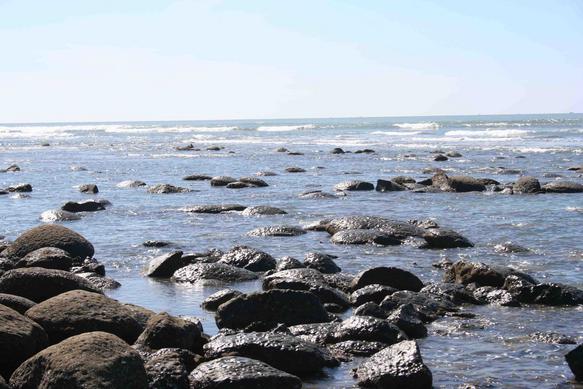
Patenga Beach

The Patenga beach at Chittagong is one of the most popular beaches of Bangladesh, stretching for miles near at the meeting place of the Bay of Bengal and the river Karnaphuli. Nature lovers come around here to enjoy the scenic sunrise and sunset. Patenga beach is about 22 km. from Chittagong and is approachable by a motorable road. On the way to the beach one passes the Patenga Airport. Another ideal picnic spot is the Fouzdarhat sea-beach about 16 km. from Chittagong.
Sitakund

About 40 km from Chittagong. This is famous for the Chandranath Hinduy Temple and the Buddist Temple. There is a hot water spring 5 km to the north of Sitakund. Other important places of interest include Shrine of Shah Amanat, Shahi Jame Mosque, Chandanpura Mosque, Portuguese Arsenal Port Area, Marine Academy, Biponi Bitan (New Market) and Government Circuit House built during British days. Accommodation, sightseeing and car hire services run by Bangladesh TRAVEL BANGLADESH (TRAVELBD) Manager (Tours), email: info@travelbd.com web site URL: www.travelbd.com
Cox's Bazar
Cox's Bazar is a town, a fishing port and district headquarters in Bangladesh. It is known for its wide sandy beach which is considered by some people as the world's longest natural sandy sea beach,although the Guinness Book of World Records lists Praia do Cassino in Brazil as the longest sandy beach with 254 km. The beach in Cox' Bazar is an unbroken 125 km sandy sea beach with a gentle slope. It is located 150 km south of the industrial port Chittagong. Cox’s Bazar is also known by the name "Panowa," the literal translation of which means "yellow flower." Its other old name was "Palongkee." The modern Cox's Bazar derives its name from Captain Hiram Cox (died 1799), an officer serving in British India. An officer of the British East India Company, Captain Cox was appointed Superintendent of Palongkee outpost after Warren Hastings became Governor of Bengal. Captain Cox was specially mobilised to deal with a century-long conflict between Arakan refugees and local Rakhains. He embarked upon the mammoth task of rehabilitating refugees in the area and made significant progress. A premature death took Captain Cox in 1799 before he could finish his work. To commemorate his role in rehabilitation work a market was established and named after him Cox's Bazar ("Cox's Market").

The tourist capital Miles of golden sands, towering cliffs, surfing waves, rare conch shells, colourful pagodas, Buddhist temples and tribes, delightful sea food this is Cox's Bazar, the tourist capital of Bangladesh. Having the world's longest unbroken (120 km) beach sloping gently down to the blue waters of the Bay of Bengal against the picturesque background of a chain of hills covered with deep green forests, Cox's Bazar is one of the most attractive tourist spots in the world. The beach is good for bathing, sun bathing and swimming. The breath taking beauty of the sun setting behind the waves of the sea is captivating. Attractive local variety of cigars and handloom products of the Rakhyne tribal families are good buys. Their unique customs and costumes attract visitors. Located at a distance of 152 km. south of Chittagong, Cox's Bazar is connected both by air and road from Dhaka and Chittagong. Visits to the fascinating picnic spot at Himchair, Teknaf, southern most tip of Bangladesh, Buddist temple at Ramu and nearby islands of Sonadia, St. Martin and Moheskhali are memorable experience of a life time. Government has taken initiatives to develop Sonadia as an exclusive beach resort. TRAVEL BANGLADESH (TRAVELBD) is an Perfect tour operator ,comfortable accommodation, catering, sightseeing and other facilities for the visitor. There is a nine hole golf course also for the guests. Day long attractive sightseeing is organized in Cox'sbazar by TRAVEL BANGLADESH (TRAVELBD) during tourist season. For bookings contact the Manager (Tours) , TRAVELBD Head Office Web site URL: www.travelbd.com, email: info@travelbd.com
Hill Tracts Districts

The Chittagong Hill Tracts / Hilly Bengal comprise an area of 13,295 km2 in southeastern Bangladesh and border India and Myanmar (Burma). They formed a single district of Bangladesh until 1984, when they were divided into three districts: Khagrachari, Rangamati, and Bandarban. Topographically, the Chittagong Hill Tracts are the only very hilly area in Bangladesh. With Ladakh, Sikkim, Bhutan, and Sri Lanka, they constitute one of the few remaining abodes of Buddhism in South Asia
world of panoramic beauty The hill Tracts Districts with its perenial forest, thrilling drives through hills and dales, emerald blue water of Kaptai lake, colourful tribal life and culture, attractive handicrafts and artisans beackons you to a world of panoramic beauty mother nature has so lavishly unfolded. Greater Hill Tracts is dividend into three districts, namely Rangamati, Khagrachari and Bandarban each one equally unique in its attractions. For visits of foreign tourists to the Hill tract districts prior permission form the Government is required which can be arranged through TRAVEL BANGLADESH (TRAVELBD) Manager (Tours), TRAVELBD email: info@travelbd.com web site URL: www.travelbd.com
Rangamati - The Heart of the Lack District

From Chittagong a 77 km. road amidt green fields and winding hills will take you to Rangamati, the headquarters of Rangamati Hill District which is a wonderful repository of scenic splendours with flora and fauna of varied descriptions. The township is located on the western bank of the Kaptai lake. Rangamati is a favourite holiday resort because of its beautiful landscape, scenic beauty, lake, colourful tribes (Chakma, Marma etc.) its flora and fauna, tribal museum, hanging bridge, homespun textile products, ivory jewellery and the tribal men and women who fashion them. For tourists the attractions of Rangamati are numerous, tribal life, fishing, speed boat cruising, water skiing, hiking, bathing or merely enjoying nature as it is. Bangladesh Parjatan Corporation provides suitable hotel and cottage accommodation, catering, speed boat and other facilities at Rangamati. Day long attractive sightseeing is organized in Cox'sbazar by TRAVEL BANGLADESH (TRAVELBD) during tourist season. For bookings Manager (Tours), TRAVELBD Head Office.Web site URL: www.travelbd.com, email: info@travelbd.com
Kaptai Lake

Kaptai Lake is a man made lake in south-eastern Bangladesh. It is located in the Kaptai Upazila under Rangamati District of Chittagong Division. The lake was created as a result of building the Kaptai Dam on the Karnaphuli River, as part of the Karnaphuli Hydro-electric project. The Kaptai Lake's average depth is 100 feet (30 m) and maximum depth is 490 feet (150 m).
A pleasant and picturesque drive of 64 km. from Chitagong brings you to huge expanse of emerald and blue water ringed with tropical forest. It is the famous man made Kaptai lake (680 sq. km) formed by damming the Kamaphuli river. Only 3 km. from Kaptai along Chittagong Road, lies the ancient Chit Morong Buddist temple having beautiful Buddist statues. Other places of interest in the Hill Tract districts include Chandraghone, Khagrachari and Bandarban all in picturesque surrounding.
Sylhet - Land of Two Leves And Bud

The Hill Tracts, Sylhet is the widely hilly district in the country. Nestled in the picturesque Surma valley amidst scenic tea plantations and lush green tropical forest, it is a prime attraction for all tourists. Its terraced tea gardens, eye catching orange groves and pineapple plantations and hills covered with tropical forests form a beautiful landscape. the Sylhet valley has a good number of haors which are big natural wetlands. During winter these haors are vast stretches of green land, but in the rainy season they turn into a turbulent sea. These haors provide sanctuary to the million of migratory birds who fly from Siberia across the Himalayas to avoid the severe cold. Srimangal in Sylhet, known as the tea capital of Bangladesh, is the main tea centre of the area. For miles and miles around, the visitor can see the tea gardens spread like green carpet over the plain land or on the sloping hills. A visit to the tea plantation in Sythet is a memorable experience Sylhet the tea granary of Bangladesh , not only has over 150 tea gardens but also proudly possesses the tree largest tea gardens in the world both in area and production. Sylhet is also known as the land of the famous Muslim saint Hazrat Shah Halal the great torch bearer of Islam to the region. The Shrine of this great saint is located at Sylhet town. Colourful Monipuri, Khasia and Garo tribes live in Sylhet. Monipuri tribal maidens are famous for their dance. Sylhet is also well known for its wide variety of exquisite handicrafts of cane and bamboo. Sylhet is linked with Dhaka by rail road and air. Source: www.travelbd.com
1 Tamabil - Jaflong Situated amidst splendid panorama, Tamabil is a border out post on Sylhet- shilong Road, about 55 km away from Sylhet town. Besides enchanting views of the area one can also have a glimpse of the waterfalls across the border from Tamabil. Jaflong is also a scenic spot nearby amidst tea gardens and rare beauty of rolling stones from hills. Other places of tourist attraction in Sylhet include Moulvibazar, Janitipur, Madhabakunda and Haripur gas field. Source: www.travelbd.com
2 Guided Tours in Bangladesh TRAVEL BANGLADESH (TRAVELBD) arranges guided package tours for groups of 2 to 10 and above from Dhaka to Sylhet. For details please contact: TRAVEL BANGLADESH (TRAVELBD) Manager (Tours), TRAVELBD, email: info@travelbd.com , web site URL: www.travelbd.com

This sanctuary of migratory birds where millions of flying
creatures congregate every winter will give you pleasure. Known as "
the land of two leaves and a bud", its terraced tea gardens, rolling
countryside, colorful tribesmen, eye-catching orange groves and
pineapple plantations, tropical jungles and exotic flora and fauna will
attract you. Also known as the land of saints and savants including
Hazrat Shah Jalal, its people are known for their hospitality and
craftsmanship. And topping it all, the famous Manipuri dance will
enliven your evenings out in the open-of course, by prior arrangement.
Exquisite handmade manipuri fabrics and bamboo products are the popular
souvenirs.
Sundarbans

The Sundarbans is the largest single block of tidal halophytic
mangrove
forest in the world.
The Sunderbans is a UNESCO World
Heritage Site covering parts of Bangladesh
and Indian
state of West Bengal.
Two-third of the Sundarbans is in Bangladesh
while rest one-third is in West
Bengal, India.
The Sundarbans National Park is a National Park, Tiger Reserve, and a Biosphere Reserve located in the
Sundarbans delta in the Indian state of West
Bengal. Sundarbans South, East and West are three protected
forests in Bangladesh. This region is densely covered by mangrove
forests,
and is one of the largest reserves for the Bengal
tiger.


Visitors need to
get permit in hand from the Divisional forest office in Khulna. Water
transport is the only means of communication for visiting the Sundarbans
from Khulna or Mongla Port. Private motor launch, speed boats, country
boats as well as mechanised vessel of Mongla Port Authority might be
hired for the purpose. From Dhaka visitors may travel by air, road or
rocket steamer to Khulna - the gateway to the Sundarbans. Most pleasant
journey from Dhaka to Khulna is by Paddle Steamer, Rocket presenting a
picturesque panorama of rural Bangladesh. Day and night-long coach
services by road are also available. The quickest mode is by air from
Dhaka to Jessore and then to Khulna by road.

Main attractions
of Sundarban wildlife photography of the famous Royal Bengal Tiger,
wildlife viewing, boating inside the forest, natur study, fishermen,
wood cutters and honey collections. Famous spot of Sundarban are Hiron
Point, Deer, Monkey, crocodiles, birds and natural beauty, katka,
morning and evening symphony of wild fowls. Bangladesh Parjatan
Corporation & other tour operators offers all-inclusive guided
package fours from Dhaka to Sundarbans and return during the tourist
season

Kuakata


The name Kuakata originated from the word 'Kua'-the Bengali word for “Well” which was dug on the sea shore by the early Rakhine settlers in quest of collecting drinking water, who landed on Kuakata coast in the eighteenth century after being expelled from Arakan (Myanmar) by the Mughals. Afterwards, it has become a tradition of digging Well in the neighborhoods of Rakhaine tribes for water.
Kuakata offers a full view of the sunrise and sunset from the same white sandy beach in the water of the Bay of Bengal. Locally known as Shagor Kannya (Daughter of the Sea), the long strip of dark, marbled sand stretches for about 30 km. The long and wide beach at Kuakata has a typical natural setting. This sandy beach has gentle slopes into the Bay of Bengal. Kuakata is also a sanctuary for migratory winter birds.


Fatra’s chor is the nice tourist place near Kuakata beach. From Kuakata traveler may visit the Fatrar Chor. Fatrar Chor is the part of the Sundarban forest. Fatrar Chor is also known as Fatrar Bon. As the Fatrar Chor is the part of Sundarban so it is mangrove forest. Fatrar Bon is fairly big forest in Kuakata.
Mahasthangarh

The country's oldest archaeological site 'Mahasthan' means a great place. Located at a distance of 18 km north of Bogra town. Mahasthangarh is the oldest archaeological site of Bangladesh on the western bank of river Karatoa. The spectacular site is an imposing landmark in the area having a fortified long enclosure. Beyond the fortified area, other ancient ruins fan out within a semicircle of about 8 km radius. Several isolated mounds, the local names of which are Govinda Bhita Temple, Khodia Pathar Mound, Mankalir Kunda, Parasuramer Bedi, Jiyat Kunda etc. surround the fortified city. This 3rd century B.C. archaeological site is still held to be of great sancitity by the Hindus. Every year (mid - April) and once in every 12 years (December) thousands of Hindu devotees join the bathing ceremony on the bank of river Karatoa. A visit to the Mahasthangarh site museum will open up for one a wide variety of antiquities, ranging form terra-cotta objects to gold ornaments and coins recovered from the site. Also noteworthy are the shrine of Shah Sultan Bulki Mahisawary and Gokul Moth in the neighbourhood of Mahasthangarh. *Guided Tours in Mahasthangarh TRAVEL BANGLADESH (TRAVELBD) arranges guided package tours for groups of 2 to 8 and above from Dhaka to Mahasthangarh. For details please contact: TRAVEL BANGLADESH (TRAVELBD) Manager (Tours), TRAVELBD Head Office email: info@travelbd.com , web site URL: www.travelbd.com

This 8th century archaeological site is still held to be of great sanctity by the Hindus. Every year ( mid-April ) and once in every 12 years (December) thousands of Hindu devotees join the ceremony on the bank of river Karatoa. A visit to the Mahasthangarh site museum will open up for you wide variety of antiquities, ranging from terra-cotta objects to gold ornaments and coins recovered from the site.
Rajshahi
Puthia :

Puthia has the largest number of historically important
Hindu structures in Bangladesh. The most amazing of the village’s
monuments is the Govinda Temple, which was erected between 1823 and 1895
by one of the maharanis of the Puthia estate. It’s a large square
structure crowned by a set of miniature ornamental towers. It’s covered
by incredibly intricate designs in terracotta depicting scenes from
Hindu epics, which give it the appearance of having been draped by a
huge red oriental carpet.

The ornate Siva Temple is an imposing and
excellent example of the five-spire Hindu style of temple architecture
common in northern India. The ornate temple has three tapering tiers
topped by four spires. It’s decorated with stone carvings and sculptural
works, which unfortunately were disfigured during the War of
Liberation. The village’s 16-century Jagannath Temple is one of the
finest examples of a hut-shaped temple: measuring only 5m (16ft) on each
side, it features a single tapering tower, which rises to a height of
10m (33ft). Its western facade is adorned with terracotta panels of
geometric design.

Puthia is 23km (14mi)
east of Rajshahi and 16km (10mi) west of Natore.
Varendra Research Museum

Situated at Rajshahi, this museum has a rich collection
of objects of Mohenjodaro and also of 16th to 19th century A.D. This is
devoted to the study of ancient history and culture. Its rich
collections contain interesting objects of past Hindu, Buddhist and
Muslim heritage. It is located at the heart of Rajshahi town and
maintained by Rajshahi University authority. The year of its formal
establishment is 1910 A.D. Admission is free.
Choto Sona Mosque

One of the most graceful monument of the Sultanate period
is the Chhota Sona Masjid or Small Golden Mosque at Gaur in Rajshahi
Built by one Wali Muhammad during the reign of Sultan Alauddin Husain
Shah (1493-1519). Originally it was roofed over with 15 gold-gilded
domes including the 3 Chauchala domes in the middle row, from which it
derives its curious name.
Ramshagor Dighi

The beautiful Ramshagor Dighi (Lake) was dug in 17th
Century by Maharaja Ram Nath to solve the water problem. This is now one
of the historical places as well as a tourist spot also.Shopnopuri is
one of the most beautiful artificial tourist spot in North Bengal. You
can go there either from Hili or from Dinajpur. There you can enjoy your
full day watching this artificial beauty.You can spend night also In
Shoponopuri rest house but for that you will have to book in advance. It
is an idle Picnic spot also where lots of picnic parties come every
year.
Kantajees Temple (Dinajpur)

Kantajee’s Temple is in Dinajpur district. It is the most
ornate among the late medieval temples of Bangladesh is the Kantajee’s
temple near Dinajpur town, which was established in the year 1722 by Ram
Nath, son of Maharaja Pran Nath .The temple, a 51' square three storied
edifice, rests on a slightly curved raised plinth of sandstone blocks,
believed to have been quarried from the ruins of the ancient city of
Bangarh near Gangharampur in West Bengal. It was originally a navaratna
temple, crowned with four richly ornamental corner towers on two stores
and a central one over the third stored. Unfortunately these ornate
towers collapsed during an earthquake at the end of the 19th century.
ln spite of this, the monument rightly claims to bathe finest extant
example of its type in brick and terracotta, built by Bengali artisans.
The central cells is surrounded on all sides by a covered verandah, each
pierced by three entrances, which are separated by equally ornate dwarf
brick pillars, Corresponding to the three delicately cusped entrances
of the balcony, the sanctum has also three richly decorated arched
openings on each face. Every inch of the temple surface is beautifully
embellished with exquisite terracotta plaques, representing flora fauna,
geometric motifs, mythological scenes and an astonishing array of
contemporary social scenes and favorite pastimes. The beautiful wall
paints of this temple tell us the story of Ramayan-Mohabharat,
Krishna-Lila and Dev-Devies.
Paharpur Buddhist Monastery

Paharpur Buddhist Monastery is another tourist attraction
of North Bengal. Paharpur is a small village 5 km. west of Jamalganj in
the greater Rajshahi district. You can go to Paharpur from Jaipur
district. Its only 10 km from Jaipur.King Dharma Pal established
Paharpur Buddhist Monastery in 7th century, which is the most important
and the largest known monastery south of the Himalayas,has been excavated. The main Mandir is in the center of
this Monastery. This 7th century archaeological find covers
approximately an area of 27 acres of land.The entire establishment,
occupying a quadrangular court, measuring more than 900 ft. externally
on each side, has high enclosure- walls about 16 ft. in thickness and
from 12 ft. to 15 ft. height. With elaborate gateway complex on the
north, there are 45 cells on the north and 44 in each of the other three
sides with a total number of 177 rooms.

The architecture of the
pyramidal cruciform temples profoundly influenced by those of South-East
Asia, especially Myanmar and Java.A small site-Museum built in 1956-57
houses the representative collection of objects recovered from the area,where you can see the statues of Buddha and Vishnu. The
excavated findings have also been preserved at the Varendra Research
Museum at Rajshahi. The antiquities of the museum include terracotta
plaques, images of different gods and goddesses, potteries, coins,
inscriptions, ornamental bricks and other minor clay objects.
Padma River

The Padma is the name used in Bangladesh for a major trans-boundary river, known in India as the main distributary of the Ganges, the river system that originated in the western Himalayas.

The Padma enters Bangladesh from India near Chapai Nababganj. It meets the Jamuna near Aricha and retains its name, but finally meets with the Meghna near Chandpur and adopts the name 'Meghna' before flowing into the Bay of Bengal.Rajshahi, a major city in western Bangladesh, is situated on the north bank of the Padma. Its maximum depth is 1,571 feet (479 m) and average depth is 968 feet (295 m).
Natore Dighpatiya Rajbari

Chalan Beel

Chalan Beel is the largest wetland of Bangladesh, covering three
districts of Natore, Sirajganj and Pabna. Covering around 1600 square
kilometers area, the Cholon Beel is located in the North-Western part of
Bangladesh. Here life and living is tied with boat and water. To get
relief from monotonous daily life, agony of family and to make change
for refreshment, you can avail the scope to make a trip at Cholon Beel
areas where you can discover a different lifestyle and extract the
special feeling. One who is familiar with living in the rocky or
mountain lands, has a scope to share reverse experience with biggest
landscape view. Such a biggest landscape is unique one all over
Bangladesh where people live surrounded by water all the year round.
Fishing and farming are the main business of peoples here. Hundreds of
families, mostly fishermen, in Cholon beel areas however, live on the
non-motorised/manual boat all the year round. If you can able to earn
several day holiday from busy life, can add a taste of different touch
of experience by making a touring in the villages of Cholon beel. You
can be experienced how simply people can lead their life and live with
happy. You also can find a real life nature, where none will dare to
disturb you when you fully engaged with fishing in the deep beel!
Hospitality of the local people also unthinkable that makes you happy
and it will take time to forget it from your mind.
.JPG)
In the day time, you
can see, people are busy with fishing or reaping paddy and other
seasonal crops. The prime adventure is to spend several nights on boat
on the silent water of the beel. If you know to swim, it’s another
comfort to you. By the help of boatmen, you can become a fisherman by
carrying fishing wheels and scope of catch fish from the beel. Most of
the year, the lands are inundated by water and people only get one crop
in a year. They have no alternatives to maintain their livelihoods
without fishing. Traveling by boat is the only means of transportation
for communication.
Mymensingh - The heart of Bengal's Folklore

1. Shilaidaha Kuthibari Carries memory of the Nobel laureate poet Rabindranath Tagore who made frequent visits to this place and used to stay in connection with the administration of his jamindari and enriched Bengali literature through his writings during that time. It is located at a distance of about 20 km. from Kushita town.
2. Shahjadpur kuthibari About 75 km. from Pabna town, it is also a historical place connected with the frequent visits of poet Rabindranath Tagore.
3. Sagardari Birth place of modern Bengali poet Michael Madhusudhan Datta who first introduced sonnet in Bengali poetry. Located at a distance of about 90 km. from Jessore town.
4. Meherpur Memorial Located at a distance of about 7 km. from the town of Meherpur. First provisional revolutionary Government of Bangladesh was declared here on 14 April during the liberation war in 1971. A monument has been built to commemorate this occasion.
National Museums


This
is the lake of dream, the lake of epic and this is the lake of Dragon.
According to the myth this lake is the home of a Dragon. The name of
this lake is BOGA LAKE. Local name of this lake is "Bogakain" lake.
This is the 2nd
highest lake in Bangladesh. Its exact height is
1200 feet above
from sea level. Boga lake is situated in Ruma thana of Bandarban
district. This lake also situated in the trail to Keokaradong,
the 2nd
highest peak of Bangladesh(3172feet).
Chimbuk Hill

Chimbuk Hill is one of the High peaks in Bangladesh Bangladesh
Chimbuk hill is the third highest mountain in Bangladesh. Chimbuk is one
of the most familiar tourist spot in Bandarban. It is just 26 kilometer
away from Bandarban sadar. Chimbuk hill is about 2500 feet high above
sea level. The road of this area is zigzag. So if you ride in a jeep it
will be charming. While your jeep is moving through the various
indigenous villages, their simplicity in human gestures will compel you
to think about our predecessors struggles to cope with to maintain
existence. They are as simple as nature. However when you are looking
down from Chimbuk, it will get you the feelings of floating over the
clouds. When it is a shiny day, you can see the shades of clouds over
the hills. The huge horizon of zigzag hills seem waves of a see. You
will also see the beauty of Chimbuk and Nilgiri.
Keokradong

The Second Highest Peak
of Mountain of Bangladesh

Keokradong is considered the second highest
peak in Bangladesh, height is 1,230 metres (4,035 ft), is located on
the border between Bangladesh and Burma.
Nafakhum

Nafakhum is One of the most beautiful place of Bangladesh Bangladesh

Nafa-khum is a
waterfall
in Bangladesh
on the Sangu River. It is among the largest waterfalls in the country
by volume of water falling.
The wild hilly river Sangu suddenly falls down here about 25–30 feet.
The falls are located in a remote area three hours' walking distance
from Remakri, Thanchi Upazila, Bandarban District. Remakri is located three hours by boat
on the Sangu River from Tindu, which is
itself three hours by boat from Thanchi.
Nafa-khum is not very popular as a tourist destination.
Travelers should reach to Bandarban first, if they are interested to
have a tour to this Nafakhum waterfall. There are many bus services to
travel to Bandarban from Dhaka City. It will cost around 450/= Taka for a
Non-Ac bus.
Remakri falls

Any one wanted to journey the Adventure then most go there.
It,s also beautiful place. The falls are located in a remote area three hours' walking distance
from Remakri , Thanchi Upazila ,
Bandarban District

Prantik Lake is really beautiful tourist spot in Bandarban district of
Bangladesh. This lake is surrounded by many kind of plants and trees.
This amazing place will certainly attract tourist
mind. Prantik Lake is an ideal place for travel. Prantik Lake located in a village named “Holudia” near the
Keranihat-Bandarban Road. It is 14km away from Bandarban town. Volume of
this area is 29 acres.


Meghla

You can also enjoy the natural beauties by paddling boat in the lake or
riding on cable car. There is a beautiful rest house to pass the leisure
time informing before going there (Booking phone: 0361-62506,
01717-2718051). There are several hotels and food canteens to serve you.
You can go there by car, jeep and baby taxi.


Shoilo Propat is the natural waterfall which is situated at Milanchari.
It is 4 km from Bandarban town. This is on the way to Thanchi. This
Shoilo Propat is an excellent site for refreshment. This Propat is
maintained by Bangladesh Parjatan corporation. You can have rent room
for night sleep there. The room rent here is little high compared to
other places. The site is also maintained by the District
Administration of Meghla, which is located 4 km from the town on the
road to Keranihat.
Rijuk waterfal

In this place creating a unique beauty of nature. This lake
is surrounded many kinds of plant. You can go there any time but during the
rainy season you will see the most attractive glance of this fall. very nice
and huge waterfall with awesome natural beauty.

Rijuk Waterfall (Rijuk Jhorna) is located at Ruma upazilla of Bandarban.
The water is continuously falls into the river Sangu from about 300
feet high hill with beautiful sound throughout the year and this water
is shiny like pearl particles in the space creating a unique beauty of
nature. This lake is surrounded by many kinds of plant and underwood.
You can go there any time but during the rainy season you will see the
most attractive glance of this fall. This awesome place will make you
the most naturalistic and very close to your heart.

Sangu river originates in the Arakan Hills of Myanmar and enters
Bangladesh near Remarki (Thanchi upazila of Bandarban district). It
flows north through Thanchi, Rowangchhari and Bandarban upazilas of
Bandarban district. Then it flows west through Satkania and Banshkhali
upazilas of Chittagong district to meet the Bay of Bengal near
Khankhanabad (Chittagong). The length of the river is 295 km. The major
tributaries of the river are Chandkhali Nadi and Dolu khal. There are 7
BWDB hydrometric stations on this river and data are available from
1965. Sangu River has its source at 21°13´N and 92°37´E in the North
Arakan Hills, which form the boundary between Arakan and the CHITTAGONG
HILL TRACTS. It follows a northerly circuitous course in the Hill Tracts
up to BANDARBAN. It enters the district from the east and flows west
across the district and finally falls into the BAY OF BENGAL at the end
of a course of 270 km (173 km within Bangladesh territory) at 22°6´N and
91°51´E about 16.09 km south of the mouth of the KARNAFULI. The
principal tributary of the Sangu is the Dolukhal, which drains the
Satkania plain. The Chand Khali flowing through the Patiya plains also
joins it on its right-bank. Further down, it is joined by the Kumira
Khali and ultimately falls into the Kutubdia Channel. The Sangu is,
therefore, a very important river in so far as it drains off the waters
of three important upazilas - PATIYA, SATKANIA and BANSHKHALI.

It has
also a connection with the Karnafuli through the Chand Khali. The Sangu
is a shallow river but it becomes violent during rains with rapid
currents. It is navigable up to 48.27 km from the estuary. The Sangu gas
field is located about 50km southwest of Chittagong and stands at a
depth of 10 meters the Bay of Bengal.
Shaila Propat

A popular tourist spot of Bandarban.It is 7 km from Bandarban town. just can hire a transportation or can
use local transport tation to reach at to the falls.Be careful when you are near to the waterfall. the surface is is very
slippery, few aciident hapend here every year
Tajingdong

Tajingdong also known as “Bijoy” is the highest mountain of
Bangladesh. Tajingdong is about 4300 ft (1310 meters) high from the sea
level. It is situated in remakri pangsha union under Ruma upazilla of
Bandarban in Bangladesh. According to local tribal language “Tajing”
means “Great” & “Dong” means “Hill” so that means “Great hill”. There are various tribal community is developed surrounding the
mountain and their living styles are so natural. This remote area is
full of natural beauty. Here you can see many small and big mountains
and hills. This area is covered with dense forests, birds and animals.
There are many tourist visits the Tajingdong Mountain in every year. It
is the place of surprising beauty. This natural beauty is surely
attracts the mind of the adventurous people. In the winter season many
adventurous tourist visit this place with great excitement. You will
pleased with the dazzling beauty of green hill, cool fountains, zigzag
path, hilly road side, hide and seek game of clouds on the top of the
hill.
For visiting Tajingdong you have to reach at Bandarban first then go to
Ruma Upazilla. Ruma is 50 kilometer away from Bandarban. You should
remember that after 4 pm you are not allowed to leave Ruma for visiting
Bogalake, Keokradong or Tajingdong. As it is a remote area of
Bangladesh, the road is not so plain. The communication systems of
Bogalake become very difficult in the Rainy season. The road is still
under construction. From Ruma you can hire a pickup or jeep (locally
known as “Chander Gari”) up to Koikhong Jiri at the fare of about Tk.
2000-200. You can also go there by buying tickets of Chander Gari or
Bus. The first trip is at 9am. It will take 1-1.30 hrs. Koikhhong Jiri
to Ruma you have to go by one hour boat journey. Again Ruma to Boga Lake
you should hire a jeep at the fare of about Tk. 1800-2000. Finally you
have to walk through the hills from Boga Lake to Tajingdong.

Remember that, this journey is very much laborious. So keep
confidence. Always carry drinking water and first aid box with you. Show
positive attitude with local people and should respect the tribal
culture.
There are some residential hotels in Ruma Bazar, so you have to
confirm at first the hotel reservation before going to Ruma, otherwise
you will have no alternative passing the night. If you are fortunate you
can get tribal house to pass the night. In Bogalake There is no other accommodation facility except the rest
houses of district council. There is no mobile network, no restaurant
and also no good road communication. You should start your journey early
in the morning from Bogalake to reach Tajingdong and it may take 7 to 8
hours to reach Tajingdong. However, the sceneries of cool air, white
clouds, hills, river and lake are really unique and incomparable. If you
go there obviously you can get an enjoyable, delightful and thrilling
experience.
Upavon Parjatan

Upabon Parjatan is another beautiful Place in Bandarban at Naikhongchari. It is
wonderful gift of nature. Here is an amazing lake surrounded by forest.


 Now Saint Martin’s is famous tourist place in Bangladesh. Saint Martin’s
Island is really an exotic feeling where you will feel and listen the
sound of Sea. It is very exciting. If you are lucky enough then you can
spend the exciting moonlight night at Saint Martin’s Island. The beauty
of Full moon in Saint Martin Island cannot be expressed, if you are not
there at that time. Saint Martin’s Island. It’s a natural beauty. Sound
of Sea, bird, coral beach, Swimming, tree, air all of are very
amazing.
Now Saint Martin’s is famous tourist place in Bangladesh. Saint Martin’s
Island is really an exotic feeling where you will feel and listen the
sound of Sea. It is very exciting. If you are lucky enough then you can
spend the exciting moonlight night at Saint Martin’s Island. The beauty
of Full moon in Saint Martin Island cannot be expressed, if you are not
there at that time. Saint Martin’s Island. It’s a natural beauty. Sound
of Sea, bird, coral beach, Swimming, tree, air all of are very
amazing.
Khagrachari

Khagrachhari is the natural wild beauty of Bangladesh. Here you can visit the tribal lifestyle of Chakmas in Khagrachari. You can also visit Alu tila hill. Approximately 100 meters long a very dark Cave is the mysterious beauty of Alu tila hill. Khagrachari hill district (east-southern region of Bangladesh) is full of hills and waterfalls. The people of hilly areas usually live on the top of the hills. The major problem for them is the crisis of drinking water on such height. The people in the hill areas are still deprived and don't have the civil facilities such as sanitation, proper education and economy. Sapchari waterfall is situated in Khagrachari Hill district and about 115 km north from Chittagong town. The waterfall is near to the sapchari village and is emerged out Alutila Hill Range situated by the Chengi River. One may go to Khagrachari by bus from chittagong city. From Khagrachari bus terminal using rickshaw or some other means s/he may reach at Khabangpujjya. Then across the Chengi river the Sapchari village is situated. In the south of the Sapchari village the Sapchari waterfall is located.

The landscape is very charismatic and the whole view of Khagrachari town can be observed from the top of the waterfall. khagrachari is one of the most naturally rich area with hills, forests, falls , the life of inhabitants and spectacular landscapes in Bangladesh. if you are a photographer you have so many subjects,if you are a tourist you have so many spots to visit. you can go Alotila(mysterious cave), Risang falls, dhiginala, marissa etc. there are so many places to explore. Tourism business is not very much organized in this country not by government and private sector and if it develop sometime khagrachari will acclaim exorbitant encomium from worldwide tourists .

The biggest fall which is called risang had been identified last year 2008 and so many falls are on waiting to identify. This area is also safe for wild animals and you can see sometime groups of wild elephants are passing the road while you are driving your car. here the parjatan motel is also one of best parjatan motel in Bangladesh. they can provide you good environment to stay, garden, small lake , nearby river, good healthy food to enjoy . it is very calm and quite place that you would to stay longer.
Saint
Martin Island
Saint Martin
Island is a small island in the northeast of the Bay of Bengal,
about 9 km south of the Cox's Bazar-Teknaf peninsular tip and forming
the southernmost part of Bangladesh. It is about 8 km west of the
northwest coast of Myanmar at the mouth of the river naf. The local name
of the coconut is Narikel and the original name of this Island is
Narikel Jinjira.The local people call it Narikel Jinjira. It is almost flat and is 3.6m
above the mean sea level. The 9.66 km wide channel between the mainland
and the island is much shallower than the open sea southwest of the
island. There are reefs from 10-15 km to the west-northwest. In this
Island, you will find the beautiful Coral reef and long Coral beach and
lots of coconut trees. You can find Keya tree only there.

| Historical Place | |||||||||||||||||||||||||||||||||||||||||||||||||||||||||||||||||
| Mausoleum of Father of The Nation | |||||||||||||||||||||||||||||||||||||||||||||||||||||||||||||||||
| |||||||||||||||||||||||||||||||||||||||||||||||||||||||||||||||||
| National Memorial | |||||||||||||||||||||||||||||||||||||||||||||||||||||||||||||||||
| |||||||||||||||||||||||||||||||||||||||||||||||||||||||||||||||||
| Central Shahid Minar | |||||||||||||||||||||||||||||||||||||||||||||||||||||||||||||||||
| |||||||||||||||||||||||||||||||||||||||||||||||||||||||||||||||||
| Martyred Intellectual Memorial | |||||||||||||||||||||||||||||||||||||||||||||||||||||||||||||||||
| |||||||||||||||||||||||||||||||||||||||||||||||||||||||||||||||||
| National Poet's Grave | |||||||||||||||||||||||||||||||||||||||||||||||||||||||||||||||||
| |||||||||||||||||||||||||||||||||||||||||||||||||||||||||||||||||
| Bahadurshah park | |||||||||||||||||||||||||||||||||||||||||||||||||||||||||||||||||
Located
at old city opposite the Jagannath University formerly Victoria Park
this memorial place of 1857 was built to commemorate the martyr's of the
first liberation war in the years of 1857-59 against British Rule. This
is the place where the revolting sepoys and their civil compatriots
were cowardly hanged. The ancient name of the place was "Antagor
Maidan".
|  | ||||||||||||||||||||||||||||||||||||||||||||||||||||||||||||||||
| Curzon Hall | |||||||||||||||||||||||||||||||||||||||||||||||||||||||||||||||||
In the wake of the first
partition of Bengal in 1905, a group of architecturally homogeneous
building was erected in Dhaka illustrating a happy blending of the
Mughal and European tastes. Massive in appearance these buildings were
characterized by a symmetrical composition of their component part and a
great variety of eye-catching external detail. The foundation stone of
Curzon Hall was laid by Lord Curzon on 14 February 1904. Its elegent
facade with its central projecting bay and wide arched horse shoe shaped
portals with windows avobe, has a attractively variegated by a series
of panels, bracketed eaves and kiosks crowning the roof, whilst the
corners are relieved with miners.
|  | ||||||||||||||||||||||||||||||||||||||||||||||||||||||||||||||||
| Baldha Garden | |||||||||||||||||||||||||||||||||||||||||||||||||||||||||||||||||
| Established in 1904, by the late Narendra Narayan Roy, the garden is located in Wari (opposite to the Christian cemetery). This garden boasts a rich collection of indigenous and exotic plants. Open: Saturday-Thursday, 9:00 a.m.-5:00 p.m. Friday closed. Entry tickets are available on the gate. |  | ||||||||||||||||||||||||||||||||||||||||||||||||||||||||||||||||
| Suhrawardy Uddayan | |||||||||||||||||||||||||||||||||||||||||||||||||||||||||||||||||
| At a stone throw distance from Dhaka Sheraton Hotel and stretching out Dhaka University campus and Bangla Academy, the Suhrawardy Uddyan, formely known as the race course, is a testament to our great historical achievement. It is here that the clarion call of independence of Bangladesh was declared on 7th March 1971 by Father of the Nation the great national leader Bangabandhu Sheikh Mujibur Rahman and it is again here that the commander of the Pakistani Occupation forces surrendered on the 16th December 1971 to the joint command. |  | ||||||||||||||||||||||||||||||||||||||||||||||||||||||||||||||||
| Old High Court Building | |||||||||||||||||||||||||||||||||||||||||||||||||||||||||||||||||
Originally
built as the residence of the British Governor, the High Court Building
illustrates a fine blend of European and mughal architecture. The
building is situated North of the Curzon Hall of Dhaka Universiry.
|  | ||||||||||||||||||||||||||||||||||||||||||||||||||||||||||||||||
| Natore - Dighapatiya Rajbari (Palace) | |||||||||||||||||||||||||||||||||||||||||||||||||||||||||||||||||
Natore
lies about 40 km. from Rajshahi and is an old seat of the Maharajah of
Dighapatiya, now serving as the Uttara Ganabhaban (The Official northern
region residance of the President of the Republic). The palace has
large, spacious grounds and is surrounded by a fine moat. The palace has
well-equipped guest-house, an imposing gateway and a fine garden
decorated with statues of white marble.
|  | ||||||||||||||||||||||||||||||||||||||||||||||||||||||||||||||||


This comment has been removed by the author.
ReplyDelete